ENR 3 ROUTES
ENR 3.1 Lower ATS routes
| Route Designator (Navigation specification) | [Route Usage Notes] | |||||||||||||
|---|---|---|---|---|---|---|---|---|---|---|---|---|---|---|
| Significant Point Name | Significant Point Coordinates | Remarks | ||||||||||||
| Track MAG | Dist (NM) | (COP) |
| Minimum flight altitude | Lateral limits (NM) | FL series | Controlling unit {Airspace class} Remarks | |||||||
| ↓ | ↑ | ||||||||||||
| Point/Segment Remarks:
(1) ANYANG VORTAC (SEL) - OSPOT Daegu ACC FREQ : 132.80 MHz 118.925 MHz 122.75 MHz1) 1) Common frequency FREQ : (at or below FL295) 128.70(118.925) MHz, 270.50(263.60) MHz FREQ : (above FL 295) 132.80(120.525) MHz, 290.60(335.45) MHz Airspace Classification Class A : Above FL 200 - FL 600 Class D : MEA - FL 200 Class G : Above FL 600 - UNL (2) OSPOT - APELA Daegu ACC FREQ : 125.375 MHz 125.775 MHz 124.575 MHz 122.75 MHz 2) 2) Common frequency FREQ : 125.375(125.775, 124.575) MHz, 234.15(317.35, 335.50) MHz Airspace Classification Class A : Above FL 200 - FL 600 Class D : MEA - FL 200 Class G : Above FL 600 - UNL | ||||||||||||||
A582 | Route availability: | |||||||||||||
| ∆ | ANYANG VORTAC (SEL) | 372449N 1265542E | ||||||||||||
| 12.4 |
| 3 400 ft AMSL | 10 | Odd | Even | (1) | |||||||
| ∆ | POLEG | 371249N 1265935E | ||||||||||||
| 7.4 |
| 3 400 ft AMSL | 10 | Odd | Even | (1) | |||||||
| ∆ | SONGTAN VORTAC (SOT) | 370540N 1270154E | ||||||||||||
| 21.6 | (69/39) |
| 3 300 ft AMSL | 10 | Odd | Even | (1) | ||||||
| ▲ | OSPOT | 365018N 1272055E | ||||||||||||
| 10.4 | (69/39) |
| 3 300 ft AMSL | 10 | Odd | Even | (2) | ||||||
| ▲ | VASLI | 364252N 1273003E | ||||||||||||
| 21.9 | (69/39) |
| 4 300 ft AMSL | 10 | Odd | Even | (2) | ||||||
| ▲ | MAKDU | 362712N 1274909E | ||||||||||||
| 14.6 | (69/39) |
| 4 400 ft AMSL | 10 | Odd | Even | (2) | ||||||
| ▲ | BITUX | 361645N 1280148E | ||||||||||||
| 39.2 | (69/39) |
| 5 200 ft AMSL | 10 | Odd | Even | (2) | ||||||
| ∆ | DALSEONG VORTAC (TGU) | 354835N 1283527E | ||||||||||||
| 20.4 |
| 5 400 ft AMSL | 10 | Odd | Even | (2) | |||||||
| ▲ | KALOD | 353012N 1284626E | ||||||||||||
| 25.4 |
| 5 400 ft AMSL | 10 | Odd | Even | (2) | |||||||
| ∆ | BUSAN VORTAC (PSN) | 350721N 1285958E | ||||||||||||
| 26.6 |
| 3 000 ft AMSL | 10 | Odd | Even | (2) | |||||||
| ▲ | APELA | 344323N 1291400E | ||||||||||||
| Route Designator (Navigation specification) | [Route Usage Notes] | |||||||||||||
|---|---|---|---|---|---|---|---|---|---|---|---|---|---|---|
| Significant Point Name | Significant Point Coordinates | Remarks | ||||||||||||
| Track MAG | Dist (NM) | (COP) |
| Minimum flight altitude | Lateral limits (NM) | FL series | Controlling unit {Airspace class} Remarks | |||||||
| ↓ | ↑ | ||||||||||||
| Point/Segment Remarks:
(1) TENAS - BUSAN VORTAC(PSN) (1) TENAS - DABIK Daegu ACC FREQ : 122.25 MHz 134.175 MHz 120.575 MHz 125.925 MHz 122.75 MHz1) 1) Common frequency FREQ : 122.250(125.925) MHz, 263.350(263.85) MHz Airspace Classification refer to ENR 3.1-1 (2) DABIK - BUSAN VORTAC(PSN) FREQ : 120.575(119.375, 119.325, 134.375) MHz, 254.70(335.75) MHz Airspace Classification refer to ENR 3.1-1 (2) BUSAN VORTAC(PSN) - TOPAX (3) BUSAN VORTAC(PSN) - TOPAX Daegu ACC FREQ : 125.375 MHz 124.575 MHz 122.75 MHz2) 2) Common frequency FREQ : 125.375(125.775, 124.575) MHz, 234.15(317.35, 335.50) MHz Airspace Classification refer to ENR 3.1-1 (3) TOPAX - MAKET (4) TOPAX - MAKET Daegu ACC FREQ : 128.175 MHz 128.325 MHz 122.75 MHz 3) 3) Common frequency FREQ : 128.175(128.325) MHz, 335.50(275.20) MHz Airspace Classification refer to ENR 3.1-1 (4) MAKET - RUGMA(FIR BDRY) (5) MAKET - RUGMA(FIR BDRY) Incheon ACC FREQ : 124.525 MHz 132.425 MHz 132.20 MHz 4) 4) Common frequency FREQ : 124.525(132.425) MHz, 255.40(233.50, 348.10) MHz Airspace Classification refer to ENR 3.1-1 ※ The cruising levels from CJU to RUGMA are even levels due to operational reasons. ※ The cruising levels from RUGMA to CJU are odd levels due to operational reasons. TENAS-PSN CDR1 Operational hour(UTC) - Weekdays : 1100-2200 - SAT: 2200 on the preceding until 2400 on the Saturday - SUN : 0000-2200 - Holiday : 1100 on the preceding until 2200 on the holiday. Rest of A586-PERM. See ENR 1.1-1.2. * A586(PSN-CJU) is only used for Non-RNAV aircraft. Any aircraft approved for RNAV operations should use Y571 or Y572. ** Any aircraft planning to operate above 10 000 ft between PSN and CJU must coordinate with Daegu ACC before flight planning. | ||||||||||||||
A586* | Route availability: | |||||||||||||
| ∆ | TENAS | 373820N 1313427E | ||||||||||||
| 68.1 |
| 4 600 ft AMSL | 10 | Even | Odd | (1) | |||||||
| ∆ | AGSUS | 364521N 1304044E | ||||||||||||
| 36.2 |
| 1 500 ft AMSL | 10 | Even | Odd | (1) | |||||||
| ▲ | DABIK | 361743N 1301143E | ||||||||||||
| 28.1 |
| 1 500 ft AMSL | 10 | Even | Odd | (1) | |||||||
| ▲ | DABIK | 361743N 1301143E | ||||||||||||
| 28.1 |
| 1 500 ft AMSL | 10 | Even | Odd | (2) | |||||||
| ▲ | BULGA | 355609N 1294924E | ||||||||||||
| 40.2 |
| 2 900 ft AMSL | 10 | Even | Odd | (1) | |||||||
| ▲ | BULGA | 355609N 1294924E | ||||||||||||
| 40.2 |
| 2 900 ft AMSL | 10 | Even | Odd | (2) | |||||||
| ▲ | BEDOM | 352513N 1291754E | ||||||||||||
| 23.1 |
| 4 000 ft AMSL | 10 | Even | Odd | (1) | |||||||
| ▲ | BEDOM | 352513N 1291754E | ||||||||||||
| 23.1 |
| 4 000 ft AMSL | 10 | Even | Odd | (2) | |||||||
| ∆ | BUSAN VORTAC (PSN) | 350721N 1285958E | ||||||||||||
| 10.4 | (79/78) |
| 3 500 ft AMSL | 10 | Even | Odd | (2) | ||||||
| ∆ | BUSAN VORTAC (PSN) | 350721N 1285958E | ||||||||||||
| 10.4 | (79/78) |
| 3 500 ft AMSL | 10 | Even | Odd | (3) | ||||||
| ∆ | OMOTU | 350033N 1285022E | ||||||||||||
| 22.3 | (79/78) |
| 3 200 ft AMSL | 10 | Even | Odd | (2) | ||||||
| ∆ | OMOTU | 350033N 1285022E | ||||||||||||
| 22.3 | (79/78) |
| 3 200 ft AMSL | 10 | Even | Odd | (3) | ||||||
| ▲ | TOPAX | 344555N 1282952E | ||||||||||||
| 46.4 | (79/78) |
| 2 800 ft AMSL | 10 | Even | Odd | (3) | ||||||
| ▲ | TOPAX | 344555N 1282952E | ||||||||||||
| 46.4 | (79/78) |
| 2 800 ft AMSL | 10 | Even | Odd | (4) | ||||||
| ▲ | GOSBO | 341517N 1274734E | ||||||||||||
| 30.7 | (79/78) |
| 2 000 ft AMSL | 10 | Even | Odd | (3) | ||||||
| ▲ | GOSBO | 341517N 1274734E | ||||||||||||
| 30.7 | (79/78) |
| 2 000 ft AMSL | 10 | Even | Odd | (4) | ||||||
| ▲ | MAKET | 335452N 1271953E | ||||||||||||
| 17.3 | (79/78) |
| 1 500 ft AMSL | 10 | Even | Odd | (4) | ||||||
| ▲ | MAKET | 335452N 1271953E | ||||||||||||
| 17.3 | (79/78) |
| 1 500 ft AMSL | 10 | Even | Odd | (5) | ||||||
| ∆ | ATINA | 334320N 1270423E | ||||||||||||
| 10.3 | (79/78) |
| 1 500 ft AMSL | 10 | Even | Odd | (4) | ||||||
| ∆ | ATINA | 334320N 1270423E | ||||||||||||
| 10.3 | (79/78) |
| 1 500 ft AMSL | 10 | Even | Odd | (5) | ||||||
| ∆ | MANOL | 333629N 1265514E | ||||||||||||
| 20.0 | (79/78) |
| 8 700 ft AMSL | 10 | Even | Odd | (5) | ||||||
| ∆ | JEJU VORTAC (CJU) | 332305N 1263727E | ||||||||||||
| 24.0 |
| 8 700 ft AMSL | 10 | Even | Odd | (5) | |||||||
| ▲ | TOSAN | 330012N 1264619E | ||||||||||||
| 31.5 |
| 1 500 ft AMSL | 10 | Even | Odd | (5) | |||||||
| ▲ | RUGMA(FIR BDRY) | 323012N 1265753E | ||||||||||||
| ∆ | MANOL | 333629N 1265514E | ||||||||||||
| 20.0 | (79/78) |
| 8 700 ft AMSL | 10 | Even | Odd | (4) | ||||||
| ∆ | JEJU VORTAC (CJU) | 332305N 1263727E | ||||||||||||
| 24.0 |
| 8 700 ft AMSL | 10 | Even | Odd | (4) | |||||||
| ▲ | TOSAN | 330012N 1264619E | ||||||||||||
| 31.5 |
| 1 500 ft AMSL | 10 | Even | Odd | (4) | |||||||
| Route Designator (Navigation specification) | [Route Usage Notes] | |||||||||||||
|---|---|---|---|---|---|---|---|---|---|---|---|---|---|---|
| Significant Point Name | Significant Point Coordinates | Remarks | ||||||||||||
| Track MAG | Dist (NM) | (COP) |
| Minimum flight altitude | Lateral limits (NM) | FL series | Controlling unit {Airspace class} Remarks | |||||||
| ↓ | ↑ | ||||||||||||
| Point/Segment Remarks:
(1) ONIKU - LAMEN Incheon ACC FREQ : (At or above FL 335) 133.425 MHz 134.15 MHz 132.20 MHz 1) 133.425(132.425) MHz, 234.35(234.65) MHz (Below FL 335) 125.725 MHz 132.825 MHz 128.375 MHz 132.20 MHz 1) 1) Common frequency 125.725(132.825, 128.375) MHz, 232.95(233.15) MHz Airspace Classification refer to ENR 3.1-1 Airspace Classification refer to ENR 3.1-1 ※ Eastbound from SADLI to ONIKU is only for Non-approval of RNAV 2. Any aircraft approved for RNAV 2 operation should use Y590. ※ Eastbound from SADLI to ONIKU is only for Non-approval of RNAV 2. Any aircraft approved for RNAV 2 operation should use Y590. 1. Delegation The responsibility of Air Traffic Services in the scope below within Incheon FIR is delegated to Shanghai ACC. - Horizontal scope : 320229N 1240000E - 321540N 1250000E - 312356N 1250000E - 311043N 1240000E - Vertical scope : FL 240 through FL 410 inclusive 2. Flight Level Allocation Scheme (FLAS) (1) The west of SADLI - Eastbound : FL 250, FL 270, FL 290, FL 310, FL 330, FL 350, FL 370, FL 390, FL 410 - Westbound : FL 240, FL 260, FL 280, FL 300, FL 320, FL 340, FL 360, FL 380, FL 400 (2) The east of SADLI - Eastbound(From Shanghai FIR To Fukuoka FIR) : FL 250, FL 290, FL 310, FL 390 - Westbound(From Fukuoka FIR To Shanghai FIR) : FL 240, FL 280, FL 300, FL 400 ※ Eastbound from SADLI to ONIKU is only for Non-approval of RNAV 2. Any aircraft approved for RNAV 2 operation should use Y590. | ||||||||||||||
A593 | Route availability: | |||||||||||||
| ▲ | ONIKU | 321142N 1263917E | ||||||||||||
| 31.4 |
| FL 240 | 50 | Even | Class A and G | ||||||||
| ▲ | ONIKU | 321142N 1263917E | ||||||||||||
| 31.4 |
| 1 500 ft AMSL | 50 | Even | (1) | ||||||||
| ∆ | NIRAT | 320354N 1260329E | ||||||||||||
| 14.5 |
| FL 240 | 50 | Even | Class A and G | ||||||||
| ∆ | NIRAT | 320354N 1260329E | ||||||||||||
| 14.5 |
| 1 500 ft AMSL | 50 | Even | (1) | ||||||||
| ∆ | PONIK | 320021N 1254659E | ||||||||||||
| 41.4 |
| FL 240 | 50 | Even | Class A and G | ||||||||
| ∆ | PONIK | 320021N 1254659E | ||||||||||||
| 41.4 |
| 1 500 ft AMSL | 50 | Odd | (1) | ||||||||
| ▲ | SADLI | 314948N 1250000E | ||||||||||||
| 52.8 |
| FL 240 | 50 | Even | Class A and G | ||||||||
| ▲ | SADLI | 314948N 1250000E | ||||||||||||
| 52.8 |
| 1 500 ft AMSL | 50 | Odd | (1) | ||||||||
| ▲ | LAMEN | 313636N 1240000E | ||||||||||||
| Route Designator (Navigation specification) | [Route Usage Notes] | |||||||||||||
|---|---|---|---|---|---|---|---|---|---|---|---|---|---|---|
| Significant Point Name | Significant Point Coordinates | Remarks | ||||||||||||
| Track MAG | Dist (NM) | (COP) |
| Minimum flight altitude | Lateral limits (NM) | FL series | Controlling unit {Airspace class} Remarks | |||||||
| ↓ | ↑ | ||||||||||||
| Point/Segment Remarks:
(1) JEJU VORTAC(CJU) - SAMDO(FIR BDRY) Incheon ACC FREQ : 124.525 MHz 132.425 MHz 132.20 MHz 2) 2) Common frequency FREQ : 124.525(132.425) MHz, 255.40(233.50, 348.10) MHz FREQ : 124.525 MHz 132.425 MHz 132.20 MHz 2) 2) Common frequency Airspace Classification refer to ENR 3.1-1 Airspace Classification refer to ENR 3.1-1 Incheon ACC Incheon ACC FREQ : 128.175 MHz 128.325 MHz 132.20 MHz 3) 3) Common frequency 128.325 MHz 132.20 MHz 3) 3) Common frequency Airspace Classification refer to ENR 3.1-1 | ||||||||||||||
A595 | Route availability: | |||||||||||||
| ▲ | JEJU VORTAC (CJU) | 332305N 1263727E | ||||||||||||
| 35.9 |
| 9 000 ft AMSL | 8 | Odd | Even | Class A, D and G | |||||||
| ∆ | JEJU VORTAC (CJU) | 332305N 1263727E | ||||||||||||
| 35.9 |
| 8 700 ft AMSL | 8 | Odd | Even | (1) | |||||||
| ∆ | TAMNA | 332815N 1271953E | ||||||||||||
| 49.8 |
| 9 000 ft AMSL | 8 | Odd | Even | Class A, D and G | |||||||
| ▲ | TAMNA | 332815N 1271953E | ||||||||||||
| 49.8 |
| 1 500 ft AMSL | 8 | Odd | Even | (1) | |||||||
| ▲ | SAMDO(FIR BDRY) | 333503N 1281857E | ||||||||||||
| Route Designator (Navigation specification) | [Route Usage Notes] | |||||||||||||
|---|---|---|---|---|---|---|---|---|---|---|---|---|---|---|
| Significant Point Name | Significant Point Coordinates | Remarks | ||||||||||||
| Track MAG | Dist (NM) | (COP) |
| Minimum flight altitude | Lateral limits (NM) | FL series | Controlling unit {Airspace class} Remarks | |||||||
| ↓ | ↑ | ||||||||||||
| Point/Segment Remarks:
(1) KANSU - IGRAS Daegu ACC FREQ : 1 22.2 5 MHz 1 25.92 5 MHz 122.75 MHz 1) 1) Common frequency FREQ : 122.250(125.925) MHz, 263.350(263.85) MHz Airspace Classification refer to ENR 3.1-1 Airspace Classification refer to ENR 3.1-1 | ||||||||||||||
B332 | Route availability: | |||||||||||||
| ▲ | KANSU(FIR BDRY) | 383800N 1322830E | ||||||||||||
| 40.2 |
| FL 200 | 50 | Odd | Even | Class A and G | |||||||
| ▲ | KANSU(FIR BDRY) | 383800N 1322830E | ||||||||||||
| 40.2 |
| 1 500 ft AMSL | 50 | Odd | Even | (1) | |||||||
| ∆ | PALDU | 375813N 1323625E | ||||||||||||
| 19.9 |
| FL 200 | 50 | Odd | Even | Class A and G | |||||||
| ∆ | PALDU | 375813N 1323625E | ||||||||||||
| 19.9 |
| 1 500 ft AMSL | 50 | Odd | Even | (1) | |||||||
| ▲ | SABET | 373829N 1324019E | ||||||||||||
| 19.9 |
| FL 200 | 50 | Odd | Even | Class A and G | |||||||
| ∆ | SABET | 373829N 1324019E | ||||||||||||
| 19.9 |
| 1 500 ft AMSL | 50 | Odd | Even | (1) | |||||||
| ▲ | IGRAS(FIR BDRY) | 371846N 1324411E | ||||||||||||
| Route Designator (Navigation specification) | [Route Usage Notes] | |||||||||||||
|---|---|---|---|---|---|---|---|---|---|---|---|---|---|---|
| Significant Point Name | Significant Point Coordinates | Remarks | ||||||||||||
| Track MAG | Dist (NM) | (COP) |
| Minimum flight altitude | Lateral limits (NM) | FL series | Controlling unit {Airspace class} Remarks | |||||||
| ↓ | ↑ | ||||||||||||
| Point/Segment Remarks:
(1) GANGWON VORTAC(KAE) - KANSU(FIR BDRY) Daegu ACC FREQ : 1 22.2 5 MHz 134. 1 75 MHz 12 5.9 25 MHz 122.75 MHz 2) 2) Common frequency FREQ : 122.250(125.925) MHz, 263.350(263.85) MHz Airspace Classification refer to ENR 3.1-1 Airspace Classification refer to ENR 3.1-1 | ||||||||||||||
B467 | Route availability: | |||||||||||||
| ▲ | GANGWON VORTAC (KAE) | 374203N 1284514E | ||||||||||||
| 47.2 |
| 8 000 ft AMSL | 10 | Odd | Even | Class A, D and G | |||||||
| ∆ | GANGWON VORTAC (KAE) | 374203N 1284514E | ||||||||||||
| 47.2 |
| 7 100 ft AMSL | 10 | Odd | Even | (1) | |||||||
| ∆ | NOMEX | 374112N 1294441E | ||||||||||||
| 25.0 |
| 8 000 ft AMSL | 10 | Odd | Even | Class A, D and G | |||||||
| ▲ | NOMEX | 374112N 1294441E | ||||||||||||
| 25.0 |
| 1 500 ft AMSL | 10 | Odd | Even | (1) | |||||||
| ∆ | BUSKO | 374033N 1301610E | ||||||||||||
| 62.2 |
| 8 000 ft AMSL | 10 | Odd | Even | Class A, D and G | |||||||
| ∆ | BUSKO | 374033N 1301610E | ||||||||||||
| 62.2 |
| 4 600 ft AMSL | 10 | Odd | Even | (1) | |||||||
| ▲ | TENAS | 373820N 1313427E | ||||||||||||
| 20.0 |
| FL 200 | 50 | Odd | Even | Class A and G | |||||||
| ∆ | TENAS | 373820N 1313427E | ||||||||||||
| 20.0 |
| 1 500 ft AMSL | 50 | Odd | Even | (1) | |||||||
| ∆ | MALSO | 375440N 1314904E | ||||||||||||
| 53.3 |
| FL 200 | 50 | Odd | Even | Class A and G | |||||||
| ∆ | MALSO | 375440N 1314904E | ||||||||||||
| 53.3 |
| 1 500 ft AMSL | 50 | Odd | Even | (1) | |||||||
| ▲ | KANSU(FIR BDRY) | 383800N 1322830E | ||||||||||||
| Route Designator (Navigation specification) |
[Route Usage Notes] | |||||||||||||
|---|---|---|---|---|---|---|---|---|---|---|---|---|---|---|
| Significant Point Name | Significant Point Coordinates | Remarks | ||||||||||||
| Track MAG | Dist (NM) | (COP) |
| Minimum flight altitude | Lateral limits (NM) | FL series | Controlling unit {Airspace class} Remarks | |||||||
| ↓ | ↑ | ||||||||||||
| Point/Segment Remarks:
(1) ANYANG VORTAC (SEL) - SONGTAN VORTAC (SOT) Daegu ACC FREQ : 132.80 MHz 128.70 MHz 122.75 MHz 1) 1) Common frequency FREQ : (at or below FL 295) 128.70(118.925) MHz, 270.50(263.60) MHz FREQ : (above FL 295) 132.80(120.525) MHz, 290.60(335.45) MHz Airspace Classification refer to ENR 3.1-1 (2) SONGTAN VORTAC (SOT) - LINTA Incheon ACC FREQ : (at or below FL 255) 126.175(134.375) MHz, 317.85(335.55) MHz FREQ : (above FL 255) 132.15(123.55) MHz, 263.15(272.60) MHz FREQ : 126.175 MHz 134.375 MHz 132.20 MHz 2) 2) Common frequency Airspace Classification refer to ENR 3.1-1 *Note B576 is only used for Non-RNAV aircraft. * Note B576 is only used for Non-RNAV aircraft. Any aircraft approved for RNAV operations should use Y711 or Y722 Any aircraft approved for RNAV operations should use Y711 or Y722. (3) LINTA - IPDAS Incheon ACC FREQ : 123.725 MHz 124.50 MHz 132.20 MHz 3) 3) Common frequency FREQ : (at or below FL 255) 120.725(128.30) MHz, 263.90(272.75) MHz FREQ : (above FL 255) 123.725(124.50) MHz, 239.25(275.40) MHz Airspace Classification refer to ENR 3.1-1 (4) IPDAS - SAMLO Incheon ACC FREQ : 124.525 MHz 132.425 MHz 132.20 MHz 4) 4) Common frequency FREQ : 124.525(132.425) MHz, 255.40(233.50, 348.10) MHz Airspace Classification refer to ENR 3.1-1 **Note Any aircraft planning to operate above FL 140 between SOT and CJU must coordinate with Incheon ACC before flight planning ** Note Any aircraft planning to operate above FL 140 between SOT and CJU must coordinate with Incheon ACC before flight planning. (5) SAMLO - ATOTI Incheon ACC FREQ : (At or above FL 335) 133.425 MHz 132.425 MHz 132.20 MHz 5) 133.425(132.425) MHz, 234.35(234.65) MHz (below FL 335) FREQ : (below FL 335) 125.725 MHz 132.825 MHz 128.375 MHz 132.20 MHz 5) 5) Common frequency 125.725(132.825, 128.375) MHz, 232.95(233.15) MHz Airspace Classification refer to ENR 3.1-1 NAVAID(DME) GAP : between 44NM from KWA and 55NM from SOT, below 10,000ft AMSL, request to controller is required to get distance information NAVAID(DME) GAP : Between 44 NM from KWA and 55 NM from SOT, below 10 000 ft AMSL, request to controller is required to get distance information. | ||||||||||||||
B576* | Route availability: | |||||||||||||
| ▲ | ANYANG VORTAC (SEL) | 372449N 1265542E | ||||||||||||
| 12.4 |
| 4 500 ft AMSL | 10 | Even | Odd | Class A, D and G | |||||||
| ∆ | ANYANG VORTAC (SEL) | 372449N 1265542E | ||||||||||||
| 12.4 |
| 3 400 ft AMSL | 10 | Even | Odd | (1) | |||||||
| ▲ | POLEG | 371249N 1265935E | ||||||||||||
| 7.4 |
| 4 500 ft AMSL | 10 | Even | Odd | Class A, D and G | |||||||
| ∆ | POLEG | 371249N 1265935E | ||||||||||||
| 7.4 |
| 3 400 ft AMSL | 10 | Even | Odd | (1) | |||||||
| ▲ | SONGTAN VORTAC (SOT) | 370540N 1270154E | ||||||||||||
| 21.5 |
| 10 | Even | Odd | |||||||||
| ∆ | SONGTAN VORTAC (SOT) | 370540N 1270154E | ||||||||||||
| 21.5 | (59/59)KUZ R-060/D 19.1 |
| 2 800 ft AMSL | 10 | Even | Odd | (2) | ||||||
| ∆ | OLMEN | 364413N 1265928E | ||||||||||||
| 21.1 |
| 10 | Even | Odd | |||||||||
| ▲ | OLMEN | 364413N 1265928E | ||||||||||||
| 21.1 | (59/59)KUZ R-060/D 19.1 |
| 3 600 ft AMSL | 10 | Even | Odd | (2) | ||||||
| ∆ | ENTEL | 362311N 1265705E | ||||||||||||
| 29.4 |
| 10 | Even | Odd | |||||||||
| ▲ | ENTEL | 362311N 1265705E | ||||||||||||
| 29.4 | (59/59)KUZ R-060/D 19.1 |
| 3 100 ft AMSL | 10 | Even | Odd | (2) | ||||||
| ∆ | RINBO | 355352N 1265349E | ||||||||||||
| 22.7 |
| 10 | Even | Odd | |||||||||
| ∆ | RINBO | 355352N 1265349E | ||||||||||||
| 22.7 | (59/59)KUZ R-060/D 19.1 |
| 3 400 ft AMSL | 10 | Even | Odd | (2) | ||||||
| ∆ | LINTA | 353116N 1265119E | ||||||||||||
| 23.8 |
| 10 | Even | Odd | |||||||||
| ▲ | LINTA | 353116N 1265119E | ||||||||||||
| 23.8 | (59/59)KUZ R-060/D 19.1 |
| 4 700 ft AMSL | 10 | Even | Odd | (3) | ||||||
| ∆ | GWANGJU VOR/DME (KWA) | 350734N 1264844E | ||||||||||||
| 52.5 |
| 10 | Even | Odd | |||||||||
| ∆ | GWANGJU VOR/DME (KWA) | 350734N 1264844E | ||||||||||||
| 52.5 | (52/52) |
| 4 700 ft AMSL | 10 | Even | Odd | (3) | ||||||
| ∆ | IPDAS | 341515N 1264301E | ||||||||||||
| 52.3 |
| 10 | Even | Odd | |||||||||
| ▲ | IPDAS | 341515N 1264301E | ||||||||||||
| 52.3 | (52/52) |
| 8 700 ft AMSL | 10 | Even | Odd | (4) | ||||||
| ▲ | JEJU VORTAC (CJU) | 332305N 1263727E | ||||||||||||
| 24.3 |
| 9 000 ft AMSL | 10 | Even | Odd | Class A,D and G | |||||||
| ∆ | JEJU VORTAC (CJU) | 332305N 1263727E | ||||||||||||
| 24.3 |
| 8 700 ft AMSL | 10 | Even | Odd | (4) | |||||||
| ▲ | SOSDO | 330012N 1262735E | ||||||||||||
| 29.5 |
| 1 500 ft AMSL | 10 | Even | Odd | (4) | |||||||
| ∆ | SAMLO | 323223N 1261536E | ||||||||||||
| 30.2 |
| 1 500 ft AMSL | 10 | Even | Odd | (5) | |||||||
| ∆ | NIRAT | 320354N 1260329E | ||||||||||||
| 18.1 |
| 1 500 ft AMSL | 10 | Even | Odd | (5) | |||||||
| ∆ | ELGEP | 314653N 1255617E | ||||||||||||
| 12.1 |
| 1 500 ft AMSL | 10 | Even | Odd | (5) | |||||||
| ▲ | TESIM | 313526N 1255128E | ||||||||||||
| 100.9 |
| 1 500 ft AMSL | 10 | Even | Odd | (5) | |||||||
| ▲ | ATOTI(FIR BDRY) | 300013N 1251154E | ||||||||||||
| ∆ | SOSDO | 330012N 1262735E | ||||||||||||
| 29.5 |
| 8 000 ft AMSL | 10 | Even | Odd | Class A, D and G | |||||||
| ∆ | SAMLO | 323223N 1261536E | ||||||||||||
| 30.2 |
| 8 000 ft AMSL | 10 | Even | Odd | Class A, D and G | |||||||
| ∆ | NIRAT | 320354N 1260329E | ||||||||||||
| 18.1 |
| 8 000 ft AMSL | 10 | Even | Odd | Class A, D and G | |||||||
| ∆ | ELGEP | 314653N 1255617E | ||||||||||||
| 12.1 |
| 8 000 ft AMSL | 10 | Even | Odd | Class A, D and G | |||||||
| ∆ | NIRAT | 320354N 1260329E | ||||||||||||
| 18.1 |
| 8 000 ft AMSL | 10 | Even | Odd | Class A, D and G | |||||||
| ∆ | TESIM | 313526N 1255128E | ||||||||||||
| 100.9 |
| 8 000 ft AMSL | 10 | Even | Odd | Class A, D and G | |||||||
| ∆ | GWANGJU VOR/DME (KWA) | 350734N 1264844E | ||||||||||||
|
| 10 | Even | Odd | (3) | |||||||||
| IPDAS | 341515N 1264301E | |||||||||||||
|
|
| |||||||||||||
| JEJU VORTAC (CJU) | 332305N 1263727E | |||||||||||||
|
|
| |||||||||||||
| SOSDO | 330012N 1262735E | |||||||||||||
|
|
| |||||||||||||
| SAMLO | 323223N 1261536E | |||||||||||||
|
|
| |||||||||||||
| NIRAT | 320354N 1260329E | |||||||||||||
|
|
| |||||||||||||
| unknown reference: | ||||||||||||||
|
|
| |||||||||||||
| unknown reference: | ||||||||||||||
|
|
| |||||||||||||
| Route Designator (Navigation specification) | [Route Usage Notes] | |||||||||||||
|---|---|---|---|---|---|---|---|---|---|---|---|---|---|---|
| Significant Point Name | Significant Point Coordinates | Remarks | ||||||||||||
| Track MAG | Dist (NM) | (COP) |
| Minimum flight altitude | Lateral limits (NM) | FL series | Controlling unit {Airspace class} Remarks | |||||||
| ↓ | ↑ | ||||||||||||
| Point/Segment Remarks:
(1) BUSAN VORTAC (PSN) - INVOK Daegu ACC FREQ : 125.375 MHz 12 5.7 75 MHz 124.575 MHz 122.75 MHz 1 ) 1 ) Common frequency FREQ : 125.375(125.775, 124.575) MHz, 234.15(317.35, 335.50) MHz Airspace Classification refer to ENR 3.1-1 Airspace Classification refer to ENR 3.1-1 | ||||||||||||||
G339 | Route availability: | |||||||||||||
| ▲ | BUSAN VORTAC (PSN) | 350721N 1285958E | ||||||||||||
| 25.6 |
| 10 000 ft AMSL | 8 | Odd | Even | Class A, D and G | |||||||
| ∆ | BUSAN VORTAC (PSN) | 350721N 1285958E | ||||||||||||
| 25.6 |
| 3 400 ft AMSL | 8 | Odd | Even | (1) | |||||||
| ▲ | INVOK(FIR BDRY) | 344719N 1291923E | ||||||||||||
| Route Designator (Navigation specification) | [Route Usage Notes] | |||||||||||||
|---|---|---|---|---|---|---|---|---|---|---|---|---|---|---|
| Significant Point Name | Significant Point Coordinates | Remarks | ||||||||||||
| Track MAG | Dist (NM) | (COP) |
| Minimum flight altitude | Lateral limits (NM) | FL series | Controlling unit {Airspace class} Remarks | |||||||
| ↓ | ↑ | ||||||||||||
| Point/Segment Remarks:
(1) ANYANG VORTAC (SEL) - GUKDO Daegu ACC FREQ : 132.80 MHz 128.70 MHz 118.925 MHz 120.525 MHz 128.70 MHz 118.925 MHz 120.525 MHz 122.75 MHz 1) 1) Common frequency FREQ: (at or below FL 295) 128.70(118.925) MHz, 270.50(263.60) MHz FREQ : (above FL 295) 132.80(120.525) MHz, 290.60(335.45) MHz Only flying westbound from KPO to SEL on G585 is authorized except ACFT departing from RKTY or RKTI. Aircraft flying eastbound from SEL to KPO at or above 11 000 ft on G585 shall get PPR 24 hours before from Daegu ACC. No PPR is needed at or below 10 000 ft. Airspace Classification refer to ENR 3.1-1 Airspace Classification refer to ENR 3.1-1 (2) GUKDO - SAPRA(FIR BDRY) Daegu ACC FREQ : 120.575 MHz 119.357 MHz 134.375 MHz 122.75 MHz2) 2) Common frequency FREQ : 125.375(125.775, 124.575) MHz, 234.15(317.35, 335.50) MHz Only flying westbound from KPO to SEL on G585 is authorized except ACFT departing from RKTY or RKTI. Aircraft flying eastbound from SEL to KPO at or above 11 000 ft on G585 shall get PPR 24 hours before from Incheon/Daegu ACC. No PPR is needed at or below 10 000 ft. Airspace Classification refer to ENR 3.1-1 Airspace Classification refer to ENR 3.1-1 | ||||||||||||||
G585 | Route availability: | |||||||||||||
| ▲ | ANYANG VORTAC (SEL) | 372449N 1265542E | ||||||||||||
| 10.7 | (50/32) |
| 8 000 ft AMSL | 8 | Odd | Even | Class A, D and G | ||||||
| ∆ | ANYANG VORTAC (SEL) | 372449N 1265542E | ||||||||||||
| 10.7 | (50/32) |
| 3 400 ft AMSL | 8 | Odd | Even | (1) | ||||||
| ▲ | KALMA | 371845N 1270645E | ||||||||||||
| 19.3 | (50/32) |
| 8 000 ft AMSL | 8 | Odd | Even | Class A, D and G | ||||||
| ∆ | KALMA | 371845N 1270645E | ||||||||||||
| 19.3 | (50/32) |
| 3 400 ft AMSL | 8 | Odd | Even | (1) | ||||||
| ∆ | KAKSO | 370745N 1272637E | ||||||||||||
| 11.5 | (50/32) |
| 8 000 ft AMSL | 8 | Odd | Even | Class A, D and G | ||||||
| ∆ | KAKSO | 370745N 1272637E | ||||||||||||
| 11.5 | (50/32) |
| 3 600 ft AMSL | 8 | Odd | Even | (1) | ||||||
| ∆ | GUKDO | 370111N 1273823E | ||||||||||||
| 9.2 | (50/32) |
| 8 000 ft AMSL | 8 | Odd | Even | Class A, D and G | ||||||
| ▲ | GUKDO | 370111N 1273823E | ||||||||||||
| 9.2 | (50/32) |
| 3 700 ft AMSL | 8 | Odd | Even | (2) | ||||||
| ∆ | ENSAL | 365554N 1274747E | ||||||||||||
| 9.2 | (50/32) |
| 8 000 ft AMSL | 8 | Odd | Even | Class A, D and G | ||||||
| ∆ | ENSAL | 365554N 1274747E | ||||||||||||
| 9.2 | (50/32) |
| 4 000 ft AMSL | 8 | Odd | Even | (2) | ||||||
| ∆ | BASEM | 365037N 1275710E | ||||||||||||
| 12.5 | (50/32) |
| 8 000 ft AMSL | 8 | Odd | Even | Class A, D and G | ||||||
| ∆ | BASEM | 365037N 1275710E | ||||||||||||
| 12.5 | (50/32) |
| 5 000 ft AMSL | 8 | Odd | Even | (2) | ||||||
| ▲ | BIGOB | 364325N 1280952E | ||||||||||||
| 9.5 | (50/32) |
| 8 000 ft AMSL | 8 | Odd | Even | Class A, D and G | ||||||
| ▲ | BIGOB | 364325N 1280952E | ||||||||||||
| 9.5 | (50/32) |
| 4 900 ft AMSL | 8 | Odd | Even | (2) | ||||||
| ∆ | YECHOEN VORDME VORDME (CUN) | 363755N 1281931E | ||||||||||||
| 30.8 | (34/34) |
| 8 000 ft AMSL | 8 | Odd | Even | Class A, D and G | ||||||
| ∆ | YECHOEN VORDME VORDME (CUN) | 363755N 1281931E | ||||||||||||
| 30.8 | (34/34) |
| 3 900 ft AMSL | 8 | Odd | Even | (2) | ||||||
| ∆ | ELAPI | 362014N 1285051E | ||||||||||||
| 37.3 | (34/34) |
| 8 000 ft AMSL | 8 | Odd | Even | Class A, D and G | ||||||
| ∆ | ELAPI | 362014N 1285051E | ||||||||||||
| 37.3 | (34/34) |
| 5 000 ft AMSL | 8 | Odd | Even | (2) | ||||||
| ▲ | POHANG VORTAC (KPO) | 355838N 1292828E | ||||||||||||
| 17.2 |
| 8 000 ft AMSL | 8 | Odd | Even | Class A, D and G | |||||||
| ∆ | POHANG VORTAC (KPO) | 355838N 1292828E | ||||||||||||
| 17.2 |
| 3 500 ft AMSL | 8 | Odd | Even | (2) | |||||||
| ▲ | BULGA | 355609N 1294924E | ||||||||||||
| 44.4 |
| 1 500 ft AMSL | 8 | Odd | Even | (2) | |||||||
| ▲ | SAPRA | 354926N 1304325E | ||||||||||||
| ∆ | BULGA | 355609N 1294924E | ||||||||||||
| 44.4 |
| 8 000 ft AMSL | 8 | Odd | Even | Class A, D and G | |||||||
| ∆ | BULGA | 355609N 1294924E | ||||||||||||
| 44.4 |
| 8 000 ft AMSL | 8 | Odd | Even | Class A, D and G | |||||||
| Route Designator (Navigation specification) |
[Route Usage Notes] | |||||||||||||
|---|---|---|---|---|---|---|---|---|---|---|---|---|---|---|
| Significant Point Name | Significant Point Coordinates | Remarks | ||||||||||||
| Track MAG | Dist (NM) | (COP) |
| Minimum flight altitude | Lateral limits (NM) | FL series | Controlling unit {Airspace class} Remarks | |||||||
| ↓ | ↑ | ||||||||||||
| Point/Segment Remarks:
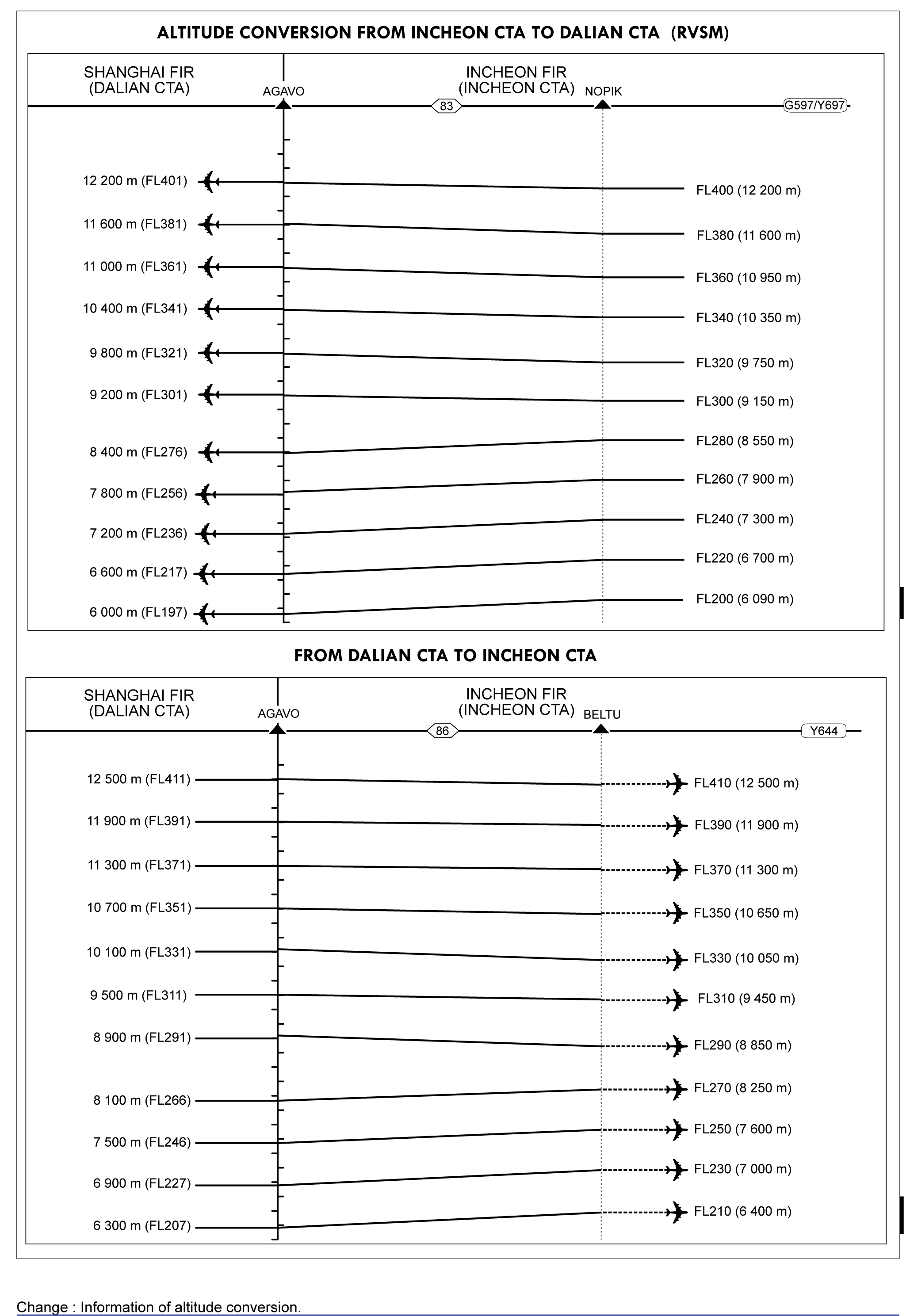
(1) AGAVO - KARBU Daegu ACC FREQ : 128.70 MHz 132.80 MHz 122.75 MHz1) 1) Common frequency FREQ : (at or below FL 295) 128.70(118.925) MHz, 270.50(263.60) MHz FREQ : (above FL 295) 132.80(120.525) MHz, 290.60(335.45) MHz Westbound(SEL-AGAVO) FL 400, FL 380, FL 360, FL 340, FL 320, FL 300, FL 280, FL 260, FL 240, FL 220, FL 200. * Note G597 is only for Non-RNAV aircraft. Any aircraft approved for RNAV operations should use Y697. Only flying westbound from SEL to AGAVO on G597 is authorized. (Unless otherwise assigned by ATC, flying eastbound in this airway shall not be used.) Aircraft flying eastbound from AGAVO to SEL on G597 shall get PPR 24 hours before from Incheon ACC. REF. ENR 3.1-9 for the detailed altitude conversion procedures. REF. ENR 3.1-10 for the detailed Altitude conversion procedures. Only flying westbound from SEL to AGAVO on G597 is authorized. (Unless otherwise assigned by ATC, flying eastbound on this airway RMK: Offset procedures on ATS route G597 (ANSIM to AGAVO) will be implemented by ATC instruction. see ENR 1.9 for the details. (2) KARBU - LANAT(FIR BDRY) Daegu ACC FREQ : (at or below FL 295) 134.175(123.65) MHz, 272.40(233.60) MHz FREQ : (above FL 295) 122.250(125.925) MHz, 263.350(263.85) MHz FREQ : 132.80 MHz 118.925 MHz 122.75 MHz2) 2) Common frequency Daegu ACC FREQ : 134.175 MHz 123.65 MHz 122.75 MHz3) 3) Common frequency Airspace Classification refer to ENR 3.1-1 Daegu ACC FREQ : 134.175 MHz 123.65 MHz 122.75 MHz4) 4) Common frequency Only flying westbound from LANAT to KAE on G597 shall get 24HRs PPR from Daegu ACC. Only flying westbound from LANAT to KAE on G597 shall get 24 HR PPR from Daegu ACC. Airspace Classification refer to ENR 3.1-1 Airspace Classification refer to ENR 3.1-1 | ||||||||||||||
G597 | Route availability: | |||||||||||||
| ▲ | AGAVO(FIR BDRY) | 371010N 1235953E | ||||||||||||
| 20.0 |
| FL 150 | 10 | Odd | Even | Class A, D and G | |||||||
| ▲ | AGAVO(FIR BDRY) | 371010N 1235953E | ||||||||||||
| 20.0 |
| 1 500 ft AMSL | 10 | Even | (1) | ||||||||
| ▲ | GONAV | 371048N 1242453E | ||||||||||||
| 13.8 |
| FL 150 | 10 | Odd | Even | Class A, D and G | |||||||
| ∆ | GONAV | 371048N 1242453E | ||||||||||||
| 13.8 |
| 1 500 ft AMSL | 10 | Even | (1) | ||||||||
| ∆ | DANTI | 371806N 1243929E | ||||||||||||
| 10.0 |
| FL 150 | 10 | Odd | Even | Class A, D and G | |||||||
| ▲ | DANTI | 371806N 1243929E | ||||||||||||
| 10.0 |
| 1 500 ft AMSL | 10 | Even | (1) | ||||||||
| ∆ | ANSIM | 372323N 1245009E | ||||||||||||
| 19.0 |
| FL 150 | 10 | Odd | Even | Class A, D and G | |||||||
| ∆ | ANSIM | 372323N 1245009E | ||||||||||||
| 19.0 |
| 1 500 ft AMSL | 10 | Even | (1) | ||||||||
| ∆ | BINIL | 372349N 1251359E | ||||||||||||
| 20.0 |
| FL 150 | 10 | Odd | Even | Class A, D and G | |||||||
| ▲ | BINIL | 372349N 1251359E | ||||||||||||
| 20.0 |
| 1 500 ft AMSL | 10 | Even | (1) | ||||||||
| ∆ | NOPIK | 372412N 1253905E | ||||||||||||
| 41.0 |
| 8 000 ft AMSL | 10 | Odd | Even | Class A, D and G | |||||||
| ▲ | NOPIK | 372412N 1253905E | ||||||||||||
| 41.0 |
| 2 200 ft AMSL | 10 | Even | (1) | ||||||||
| ∆ | GOGET | 372442N 1263036E | ||||||||||||
| 20.0 |
| 8 000 ft AMSL | 10 | Odd | Even | Class A, D and G | |||||||
| ∆ | GOGET | 372442N 1263036E | ||||||||||||
| 20.0 |
| 3 400 ft AMSL | 10 | Even | (1) | ||||||||
| ▲ | ANYANG VORTAC (SEL) | 372449N 1265542E | ||||||||||||
| 22.0 | (44/45) |
| 7 500 ft AMSL | 10 | Odd | Even | Class A, D and G | ||||||
| ∆ | ANYANG VORTAC (SEL) | 372449N 1265542E | ||||||||||||
| 22.0 | (44/45) |
| 3 500 ft AMSL | 10 | Odd | Even | (1) | ||||||
| ∆ | EGOBA | 372915N 1272246E | ||||||||||||
| 13.9 | (44/45) |
| 7 500 ft AMSL | 10 | Odd | Even | Class A, D and G | ||||||
| ∆ | EGOBA | 372915N 1272246E | ||||||||||||
| 13.9 | (44/45) |
| 5 100 ft AMSL | 10 | Odd | Even | (1) | ||||||
| ∆ | KARBU | 373159N 1273952E | ||||||||||||
| 44.7 | (44/45) |
| 7 500 ft AMSL | 10 | Odd | Even | Class A, D and G | ||||||
| ▲ | KARBU | 373159N 1273952E | ||||||||||||
| 22.9 | (44/45) |
| 5 600 ft AMSL | 10 | Odd | Even | (2) | ||||||
| ▲ | TORUS | 373625N 1280807E | ||||||||||||
| 21.8 | (44/45) |
| 7 500 ft AMSL | 10 | Odd | Even | (2) | ||||||
| ▲ | BIKSI | 374032N 1283504E | ||||||||||||
| 8.2 | (44/45) |
| 7 100 ft AMSL | 10 | Odd | Even | (2) | ||||||
| ∆ | GANGWON VORTAC (KAE) | 374203N 1284514E | ||||||||||||
| 30.0 |
| 7 100 ft AMSL | 10 | Odd | Even | (2) | |||||||
| ▲ | PILIT | 372631N 1291731E | ||||||||||||
| 27.5 |
| 3 100 ft AMSL | 10 | Odd | Even | (2) | |||||||
| ▲ | NIMUS | 371210N 1294656E | ||||||||||||
| 50.8 |
| 1 500 ft AMSL | 10 | Odd | Even | (2) | |||||||
| ∆ | AGSUS | 364521N 1304044E | ||||||||||||
| 42.9 |
| 1 500 ft AMSL | 10 | Odd | Even | (2) | |||||||
| ▲ | LANAT(FIR BDRY) | 362224N 1312542E | ||||||||||||
| ∆ | unknown reference: SP-TORUS | |||||||||||||
| 21.8 | (44/45) |
| 7 500 ft AMSL | 10 | Odd | Even | Class A, D and G | ||||||
| ∆ | BIKSI | 374032N 1283504E | ||||||||||||
| 8.2 | (44/45) |
| 7 500 ft AMSL | 10 | Odd | Even | Class A, D and G | ||||||
| ▲ | GANGWON VORTAC (KAE) | 374203N 1284514E | ||||||||||||
| 30.0 |
| 8 000 ft AMSL | 10 | Odd | Even | Class A, D and G | |||||||
| ▲ | PILIT | 372631N 1291731E | ||||||||||||
| 78.3 |
| 9 000 ft AMSL | 10 | Odd | Even | Class A, D and G | |||||||
| ∆ | AGSUS | 364521N 1304044E | ||||||||||||
| 42.9 |
| 9 000 ft AMSL | 10 | Odd | Even | Class A, D and G | |||||||
| Route Designator (Navigation specification) | [Route Usage Notes] | |||||||||||||
|---|---|---|---|---|---|---|---|---|---|---|---|---|---|---|
| Significant Point Name | Significant Point Coordinates | Remarks | ||||||||||||
| Track MAG | Dist (NM) | (COP) |
| Minimum flight altitude | Lateral limits (NM) | FL series | Controlling unit {Airspace class} Remarks | |||||||
| ↓ | ↑ | ||||||||||||
| Point/Segment Remarks:
(1) PILIT - LOSTO Daegu ACC FREQ : (at or below FL 295) 134.175(123.65) MHz, 272.40(233.60) MHz FREQ : (above FL 295) 122.250(125.925) MHz, 263.350(263.85) MHz FREQ : 134.175 MHz 120.575 MHz 123.65 MHz 119.375 MHz 122.75 MHz 1) 1) Common frequency 1. 11 000 ft to FL 240, at or above FL 280 will be blocked. 2. At or above 11 000 ft, required 15 days PPR from Air Traffic Management Office. 3. Airspace Classification refer to ENR 3.1-1 (2) LOSTO - BUSAN VORTAC(PSN) Daegu ACC FREQ : 120.575(119.375, 119.325, 134.375) MHz, 254.70(335.75) MHz 1. 11 000 ft to FL 240, at or above FL 280 will be blocked. 2. At or above 11 000 ft, required 15 days PPR from Air Traffic Management Office. 3. Airspace Classification refer to ENR 3.1-1 | ||||||||||||||
V11 | Route availability: | |||||||||||||
| ▲ | PILIT | 372631N 1291731E | ||||||||||||
| 19.3 |
| 7 000 ft AMSL | 8 | Even | Odd | (1) | |||||||
| ▲ | NOBUT | 370715N 1291957E | ||||||||||||
| 47.2 |
| 6 400 ft AMSL | 8 | Even | Odd | (1) | |||||||
| ▲ | LOSTO | 362016N 1292548E | ||||||||||||
| 21.7 |
| 3 300 ft AMSL | 8 | Even | Odd | (2) | |||||||
| ∆ | POHANG VORTAC (KPO) | 355838N 1292828E | ||||||||||||
| 37.2 |
| 4 200 ft AMSL | 8 | Even | Odd | (2) | |||||||
| ▲ | APARU | 352442N 1290932E | ||||||||||||
| 19.0 |
| 4 400 ft AMSL | 8 | Even | Odd | (2) | |||||||
| ∆ | BUSAN VORTAC (PSN) | 350721N 1285958E | ||||||||||||
| ∆ | BUSAN VORTAC (PSN) | 350721N 1285958E | ||||||||||||
| 19.3 |
| 9 000 ft AMSL | 8 | Even | Odd | Class A, D and G | |||||||
| ▲ | PILIT | 372631N 1291731E | ||||||||||||
| 47.2 |
| 9 000 ft AMSL | 8 | Even | Odd | Class A, D and G | |||||||
| ∆ | NOBUT | 370715N 1291957E | ||||||||||||
| 21.7 |
| 9 000 ft AMSL | 8 | Even | Odd | Class A, D and G | |||||||
| ∆ | LOSTO | 362016N 1292548E | ||||||||||||
| 37.2 |
| 9 000 ft AMSL | 8 | Even | Odd | Class A, D and G | |||||||
| ▲ | POHANG VORTAC (KPO) | 355838N 1292828E | ||||||||||||
| 19.0 |
| 9 000 ft AMSL | 8 | Even | Odd | Class A, D and G | |||||||
| ∆ | APARU | 352442N 1290932E | ||||||||||||
|
|
| |||||||||||||
| ▲ | BUSAN VORTAC (PSN) | 350721N 1285958E | ||||||||||||
| 37.2 |
| 9 000 ft AMSL | 8 | Even | Odd | (1) | |||||||
| ∆ | BUSAN VORTAC (PSN) | 350721N 1285958E | ||||||||||||
|
| |||||||||||||
| ∆ | BUSAN VORTAC (PSN) | 350721N 1285958E | ||||||||||||
|
|
| |||||||||||||
| Route Designator (Navigation specification) | [Route Usage Notes] | |||||||||||||
|---|---|---|---|---|---|---|---|---|---|---|---|---|---|---|
| Significant Point Name | Significant Point Coordinates | Remarks | ||||||||||||
| Track MAG | Dist (NM) | (COP) |
| Minimum flight altitude | Lateral limits (NM) | FL series | Controlling unit {Airspace class} Remarks | |||||||
| ↓ | ↑ | ||||||||||||
| Point/Segment Remarks:
(1) DALSU - TEDAN Incheon ACC FREQ : (at or below FL 255) 120.725(128.30) MHz, 263.90(272.75) MHz FREQ : (above FL 255) 123.725(124.50) MHz, 239.25(275.40) MHz FREQ : 120.725 MHz 128.30 MHz 125.375 MHz 120.575 MHz 132.20 MHz 1) 122.75 MHz 1) 1) Common frequency Airspace Classification refer to ENR 3.1-1 (2) TEDAN - BUSAN VORTAC(PSN) Daegu ACC FREQ : 128.175(128.325) MHz, 335.50(275.20) MHz Airspace Classification refer to ENR 3.1-1 | ||||||||||||||
V543 | Route availability: | |||||||||||||
| ∆ | DALSU | 350731N 1264206E | ||||||||||||
| 5.4 |
| 8 000 ft AMSL | 10 | Odd | Even | Class A, D and G | |||||||
| ∆ | DALSU | 350731N 1264206E | ||||||||||||
| 5.4 |
| 2 500 ft AMSL | 10 | Odd | Even | (1) | |||||||
| ∆ | GWANGJU VOR/DME (KWA) | 350734N 1264844E | ||||||||||||
| 2.6 | (25/83) |
| 8 000 ft AMSL | 10 | Odd | Even | Class A,D and G | ||||||
| ∆ | GWANGJU VOR/DME (KWA) | 350734N 1264844E | ||||||||||||
| 2.6 | (25/83) |
| 2 000 ft AMSL | 10 | Odd | Even | (1) | ||||||
| ∆ | SAMUL | 350736N 1265154E | ||||||||||||
| 22.1 | (25/83) |
| 8 000 ft AMSL | 10 | Odd | Even | Class A, D and G | ||||||
| ∆ | SAMUL | 350736N 1265154E | ||||||||||||
| 22.1 | (25/83) |
| 5 200 ft AMSL | 10 | Odd | Even | (1) | ||||||
| ∆ | TEDAN | 350744N 1271852E | ||||||||||||
| 13.5 | (25/83) |
| 8 000 ft AMSL | 10 | Odd | Even | Class A, D and G | ||||||
| ▲ | TEDAN | 350744N 1271852E | ||||||||||||
| 13.5 | (25/83) |
| 8 000 ft AMSL | 10 | Odd | (2) | |||||||
| ∆ | ANUBA | 350746N 1273523E | ||||||||||||
| 44.7 | (25/83) |
| 8 000 ft AMSL | 10 | Odd | Even | Class A, D and G | ||||||
| ∆ | ANUBA | 350746N 1273523E | ||||||||||||
| 44.7 | (25/83) |
| 8 000 ft AMSL | 10 | Odd | Even | (2) | ||||||
| ∆ | SAPDI | 350737N 1282952E | ||||||||||||
| 1.6 | (25/83) |
| 8 000 ft AMSL | 10 | Odd | Even | Class A, D and G | ||||||
| ▲ | SAPDI | 350737N 1282952E | ||||||||||||
| 1.6 | (25/83) |
| 3 800 ft AMSL | 10 | Odd | Even | (2) | ||||||
| ∆ | SARAM | 350736N 1283147E | ||||||||||||
| 23.1 |
| 8 000 ft AMSL | 10 | Odd | Even | Class A,D and G | |||||||
| ▲ | SARAM | 350736N 1283147E | ||||||||||||
| 11.9 | (25/83) |
| 4 000 ft AMSL | 10 | Odd | Even | (2) | ||||||
| ∆ | ANKUS | 350730N 1284616E | ||||||||||||
| 11.2 | (25/83) |
| 3 500 ft AMSL | 10 | Odd | Even | (2) | ||||||
| ∆ | BUSAN VORTAC (PSN) | 350721N 1285958E | ||||||||||||
| ∆ | BUSAN VORTAC (PSN) | 350721N 1285958E | ||||||||||||
|
|
| |||||||||||||
| ▲ | BUSAN VORTAC (PSN) | 350721N 1285958E | ||||||||||||
|
|
| |||||||||||||
| Route Designator (Navigation specification) | [Route Usage Notes] | |||||||||||||
|---|---|---|---|---|---|---|---|---|---|---|---|---|---|---|
| Significant Point Name | Significant Point Coordinates | Remarks | ||||||||||||
| Track MAG | Dist (NM) | (COP) |
| Minimum flight altitude | Lateral limits (NM) | FL series | Controlling unit {Airspace class} Remarks | |||||||
| ↓ | ↑ | ||||||||||||
| Point/Segment Remarks:
(1) GWANGJU VOR(KWA) - IGDOK Incheon ACC FREQ : (at or below FL 255) 120.725(128.30) MHz, 263.90(272.75) MHz FREQ : (above FL 255) 123.725(124.50) MHz, 239.25(275.40) MHz FREQ : 120.725 MHz 128.30 MHz 125.375 MHz 120.575 MHz 132.20 MHz 2) 122.75 MHz 2) 2) Common frequency Airspace Classification refer to ENR 3.1-1 (2) IGDOK - DALSEONG VORTAC(TGU) Daegu ACC FREQ : 128.175(128.325) MHz, 335.50(275.20) MHz Airspace Classification refer to ENR 3.1-1 | ||||||||||||||
V547 | Route availability: | |||||||||||||
| ∆ | GWANGJU VOR/DME (KWA) | 350734N 1264844E | ||||||||||||
| 54.7 |
| 10 | Odd | Even | Class D | ||||||||
| ∆ | GWANGJU VOR/DME (KWA) | 350734N 1264844E | ||||||||||||
| 54.7 | (48/48) |
| 8 600 ft AMSL | 10 | Odd | Even | (1) | ||||||
| ∆ | IGDOK | 353104N 1274907E | ||||||||||||
| 41.6 |
| 10 | Odd | Even | Class D | ||||||||
| ▲ | IGDOK | 353104N 1274907E | ||||||||||||
| 41.6 | (48/48) |
| 5 000 ft AMSL | 10 | Odd | Even | (2) | ||||||
| ∆ | DALSEONG VORTAC (TGU) | 354835N 1283527E | ||||||||||||
| ∆ | DALSEONG VORTAC (TGU) | 354835N 1283527E | ||||||||||||
|
|
| |||||||||||||
| ▲ | DALSEONG VORTAC (TGU) | 354835N 1283527E | ||||||||||||
|
|
| |||||||||||||
| Route Designator (Navigation specification) | [Route Usage Notes] | |||||||||||||
|---|---|---|---|---|---|---|---|---|---|---|---|---|---|---|
| Significant Point Name | Significant Point Coordinates | Remarks | ||||||||||||
| Track MAG | Dist (NM) | (COP) |
| Minimum flight altitude | Lateral limits (NM) | FL series | Controlling unit {Airspace class} Remarks | |||||||
| ↓ | ↑ | ||||||||||||
| Point/Segment Remarks:
(1) GUNSAN VORTAC (KUZ) - OPEDA Incheon ACC FREQ: (at or below FL 255) 126.175(134.375) MHz, 317.85(335.55) MHz FREQ : (above FL 255) 132.15(123.55) MHz, 263.15(272.60) MHz FREQ : 1 3 2 .1 5 MHz 12 6.1 75 MHz 12 3.5 5 MHz 132.20 MHz 1) 122.75 MHz 1) 1) Common frequency Airspace Classification refer to ENR 3.1-1 (2) OPEDA - POHANG VORTAC (KPO) Daegu ACC FREQ : 125.375(125.775, 124.575) MHz, 234.15(317.35, 335.50) MHz FREQ : 125.375 MHz 125.775 MHz 124.575 MHz 122.75 MHz2) 2) Common frequency Airspace Classification refer to ENR 3.1-1 Airspace Classification refer to ENR 3.1-1 TGU is used Between TGU and KPO TGU is used between TGU and KPO. | ||||||||||||||
V549 | Route availability: | |||||||||||||
| ▲ | GUNSAN VORTAC (KUZ) | 355437N 1263641E | ||||||||||||
| 8.5 | (49/48) |
| 10 | Odd | Even | Class D | |||||||
| ∆ | GUNSAN VORTAC (KUZ) | 355437N 1263641E | ||||||||||||
| 8.5 | (49/48) |
| 1 800 ft AMSL | 10 | Odd | Even | (1) | ||||||
| ∆ | ELPOS | 355410N 1264707E | ||||||||||||
| 5.5 | (49/48) |
| 10 | Odd | Even | Class D | |||||||
| ∆ | ELPOS | 355410N 1264707E | ||||||||||||
| 5.5 | (49/48) |
| 1 800 ft AMSL | 10 | Odd | Even | (1) | ||||||
| ∆ | RINBO | 355352N 1265349E | ||||||||||||
| 17.8 | (49/48) |
| 10 | Odd | Even | Class D | |||||||
| ∆ | RINBO | 355352N 1265349E | ||||||||||||
| 17.8 | (49/48) |
| 3 500 ft AMSL | 10 | Odd | Even | (1) | ||||||
| ∆ | MELES | 355251N 1271542E | ||||||||||||
| 17.2 | (49/48) |
| 10 | Odd | Even | Class D | |||||||
| ∆ | MELES | 355251N 1271542E | ||||||||||||
| 17.2 | (49/48) |
| 5 000 ft AMSL | 10 | Odd | Even | (1) | ||||||
| ▲ | OPEDA | 355149N 1273652E | ||||||||||||
| 47.7 |
| 10 | Odd | Even | Class D | ||||||||
| ∆ | OPEDA | 355149N 1273652E | ||||||||||||
| 47.7 | (49/48) |
| 6 600 ft AMSL | 10 | Odd | Even | (2) | ||||||
| ▲ | DALSEONG VORTAC (TGU) | 354835N 1283527E | ||||||||||||
| 24.6 |
| 6 000 ft AMSL | 10 | Odd | Even | Class A, D AND G | |||||||
| ∆ | DALSEONG VORTAC (TGU) | 354835N 1283527E | ||||||||||||
| 24.6 |
| 5 400 ft AMSL | 10 | Odd | Even | (2) | |||||||
| ∆ | LAPAL | 355413N 1290452E | ||||||||||||
| 19.7 |
| 6 000 ft AMSL | 10 | Odd | Even | Class A, D AND G | |||||||
| ▲ | LAPAL | 355413N 1290452E | ||||||||||||
| 19.7 |
| 5 400 ft AMSL | 10 | Odd | Even | (2) | |||||||
| ∆ | POHANG VORTAC(KPO) | 355838N 1292828E | ||||||||||||
| ∆ | POHANG VORTAC (KPO) | 355838N 1292828E | ||||||||||||
|
|
| |||||||||||||
| ▲ | POHANG VORTAC (KPO) | 355838N 1292828E | ||||||||||||
|
|
| |||||||||||||
| Route Designator (Navigation specification) | [Route Usage Notes] | |||||||||||||
|---|---|---|---|---|---|---|---|---|---|---|---|---|---|---|
| Significant Point Name | Significant Point Coordinates | Remarks | ||||||||||||
| Track MAG | Dist (NM) | (COP) |
| Minimum flight altitude | Lateral limits (NM) | FL series | Controlling unit {Airspace class} Remarks | |||||||
| ↓ | ↑ | ||||||||||||
| Point/Segment Remarks:
(1) GWANGJU TACAN (KWJ) - RUNIT Incheon ACC FREQ : (at or below FL 255) 120.725(128.30) MHz, 263.90(272.75) MHz FREQ : (above FL 255) 123.725(124.50) MHz, 239.25(275.40) MHz FREQ : 123.725 MHz 124.50 MHz 132.20 MHz3) 3 ) Common frequency Between RIMPO and RUNIT 11 000 ft AMSL to FL 190 VMC-IMC use for training purpose. Airspace Classification refer to ENR 3.1-1 (2) RUNIT - BUSAN VORTAC (PSN) Daegu ACC FREQ : 128.175(128.325) MHz, 335.50(275.20) MHz FREQ : 125.375 MHz 125.775 MHz 124.575 MHz 122.75 MHz4) 4) Common frequency Between RIMPO and RUNIT 11 000 ft AMSL to FL 190 VMC-IMC use for training purpose. Airspace Classification refer to ENR 3.1-1 Airspace Classification refer to ENR 3.1-1 | ||||||||||||||
W45 | Route availability: | |||||||||||||
| ▲ | GWANGJU TACAN TACAN (KWJ) | 350723N 1264810E | ||||||||||||
| 38.4 | (23/85) |
| 8 000 ft AMSL | 10 | Odd | Even | Class A, D AND G | ||||||
| ▲ | GWANGJU TACAN TACAN (KWJ) | 350723N 1264810E | ||||||||||||
| 38.4 | (23/85) |
| 8 000 ft AMSL | 10 | Odd | Even | Class A, D AND G | ||||||
| ∆ | GWANGJU TACAN TACAN (KWJ) | 350723N 1264810E | ||||||||||||
| 38.4 | (23/85) |
| 8 000 ft AMSL | 10 | Odd | Even | (1) | ||||||
| ∆ | unknown reference: SP-RIMPO | |||||||||||||
| 45.1 | (23/85) |
| 8 000 ft AMSL | 10 | Odd | Even | ClassA, D AND G | ||||||
| ∆ | RIMPO | 350739N 1273502E | ||||||||||||
| 45.1 | (23/85) |
| 8 000 ft AMSL | 10 | Odd | Even | (1) | ||||||
| ∆ | unknown reference: SP-RUNIT | |||||||||||||
| 24.7 | (23/85) |
| 4 000 ft AMSL | 10 | Odd | Even | Class A, D AND G | ||||||
| ▲ | RUNIT | 350734N 1282952E | ||||||||||||
| 24.7 | (23/85) |
| 4 000 ft AMSL | 10 | Odd | Even | (2) | ||||||
| ∆ | BUSAN VORTAC (PSN) | 350721N 1285958E | ||||||||||||
|
|
| |||||||||||||
| ∆ | BUSAN VORTAC (PSN) | 350721N 1285958E | ||||||||||||
| ▲ | BUSAN VORTAC (PSN) | 350721N 1285958E | ||||||||||||
|
|
| |||||||||||||
| Route Designator (Navigation specification) | [Route Usage Notes] | |||||||||||||
|---|---|---|---|---|---|---|---|---|---|---|---|---|---|---|
| Significant Point Name | Significant Point Coordinates | Remarks | ||||||||||||
| Track MAG | Dist (NM) | (COP) |
| Minimum flight altitude | Lateral limits (NM) | FL series | Controlling unit {Airspace class} Remarks | |||||||
| ↓ | ↑ | ||||||||||||
| Point/Segment Remarks:
(1) SONGTAN VORTAC (SOT) - GOGET Daegu ACC FREQ : (at or below FL 295) 128.70(118.925) MHz, 270.50(263.60) MHz FREQ : (above FL 295) 132.80(120.525) MHz, 290.60(335.45) MHz FREQ : 128.70 MHz 132.80 MHz 122.75 MHz1) 1) Common frequency Airspace Classification refer to ENR 3.2-1 Airspace Classification refer to ENR 3.1-1 | ||||||||||||||
W61 | Route availability: | |||||||||||||
| ▲ | SONGTAN VORTAC (SOT) | 370540N 1270154E | ||||||||||||
| 11.7 |
| 8000 ft AMSL | 10 | Even | Odd | Class A, D AND G | |||||||
| ∆ | SONGTAN VORTAC (SOT) | 370540N 1270154E | ||||||||||||
| 11.7 |
| 2 400 ft AMSL | 10 | Even | Odd | (1) | |||||||
| ∆ | MONSI | 371247N 1265015E | ||||||||||||
| 19.7 |
| 8000 ft AMSL | 10 | Even | Odd | Class A, D AND G | |||||||
| ▲ | MONSI | 371247N 1265015E | ||||||||||||
| 19.7 |
| 3 200 ft AMSL | 10 | Even | Odd | (1) | |||||||
| ∆ | GOGET | 372442N 1263036E | ||||||||||||
| Route Designator (Navigation specification) | [Route Usage Notes] | |||||||||||||
|---|---|---|---|---|---|---|---|---|---|---|---|---|---|---|
| Significant Point Name | Significant Point Coordinates | Remarks | ||||||||||||
| Track MAG | Dist (NM) | (COP) |
| Minimum flight altitude | Lateral limits (NM) | FL series | Controlling unit {Airspace class} Remarks | |||||||
| ↓ | ↑ | ||||||||||||
| Point/Segment Remarks:
(1) SONGTAN VORTAC (SOT) - EGOBA Daegu ACC FREQ : (at or below FL 295) 128.70(118.925) MHz, 270.50(263.60) MHz FREQ : (above FL 295) 132.80(120.525) MHz 290.60(335.45) MHz FREQ : 128.70MHz 132.80MHz 122.75 MHz2) 2) Common frequency Airspace Classification refer to ENR 3.1-1 | ||||||||||||||
W62 | Route availability: | |||||||||||||
| ▲ | SONGTAN VORTAC (SOT) | 370540N 1270154E | ||||||||||||
| 28.8 |
| FL 140 | 10 | Odd | Even | Class A AND G | |||||||
| ∆ | SONGTAN VORTAC (SOT) | 370540N 1270154E | ||||||||||||
| 28.8 |
| 4 600 ft AMSL | 10 | Odd | Even | (1) | |||||||
| ∆ | EGOBA | 372915N 1272246E | ||||||||||||
| Route Designator (Navigation specification) | [Route Usage Notes] | |||||||||||||
|---|---|---|---|---|---|---|---|---|---|---|---|---|---|---|
| Significant Point Name | Significant Point Coordinates | Remarks | ||||||||||||
| Track MAG | Dist (NM) | (COP) |
| Minimum flight altitude | Lateral limits (NM) | FL series | Controlling unit {Airspace class} Remarks | |||||||
| ↓ | ↑ | ||||||||||||
| Point/Segment Remarks:
(1) DALSEONG VORTAC (TGU) - TOPAX Daegu ACC FREQ : 125.375(125.775, 124.575) MHz, 234.15(317.35, 335.50) MHz FREQ : 125.375 MHz 125.775MHz 124.575 MHz 122.75 MHz 3) 3) Common frequency Airspace Classification refer to ENR 3.1-1 | ||||||||||||||
W526 | Route availability: | |||||||||||||
| ▲ | DALSEONG VORTAC (TGU) | 354835N 1283527E | ||||||||||||
| 19.8 |
| 5 000 ft AMSL | 10 | Even | Odd | Class A, D AND G | |||||||
| ∆ | DALSEONG VORTAC (TGU) | 354835N 1283527E | ||||||||||||
| 19.8 |
| 4 900 ft AMSL | 10 | Even | Odd | (1) | |||||||
| ∆ | MASTA | 352847N 1283340E | ||||||||||||
| 21.2 |
| 5 000 ft AMSL | 10 | Even | Odd | Class A, D AND G | |||||||
| ▲ | MASTA | 352847N 1283340E | ||||||||||||
| 21.2 |
| 3 800 ft AMSL | 10 | Even | Odd | (1) | |||||||
| ∆ | SARAM | 350736N 1283147E | ||||||||||||
| 21.7 |
| 5 000 ft AMSL | 10 | Even | Odd | Class A, D AND G | |||||||
| ▲ | SARAM | 350736N 1283147E | ||||||||||||
| 21.7 |
| 3 200 ft AMSL | 10 | Even | Odd | (1) | |||||||
| ▲ | TOPAX | 344555N 1282952E | ||||||||||||